
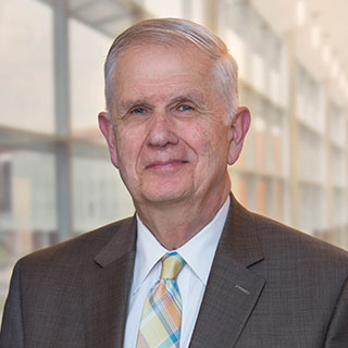
The National Oceanic and Atmospheric Administration (NOAA) has reappointed Dr. David Maune, PSM, PS, GS, CP, CFM, to its Hydrographic Services Review Panel, which according to the agency “gives NOAA independent advice for improving a range of services
and products that support safe navigation and coastal resilience.” Maune will serve another four-year term on the panel.
Maune also serves as the co-chair of the panel’s Planning and Engagement Working Group, which plans future activities and champions the preparation of issue papers with recommendations to the NOAA administrator.
According to the director of NOAA’s Office of Coast Survey, Rear Admiral Shepard M. Smith, “Panel members give NOAA critical perspectives on the needs of the maritime sector which are extremely valuable in our mission to improve the safety
and efficiency of maritime navigation.”
About David Maune, PhD
Maune is an associate vice president and serves as a senior project manager with Dewberry’s geospatial group. With nearly 60 years of experience, Maune is recognized as the industry’s leading authority on Digital Elevation Models (DEMs) and
lidar. He is the editor and principal author of “Digital Elevation Model Technologies and Applications: The DEM Users Manual” for which publication of the 3rd edition is pending. He has managed major mapping programs for NOAA, the U.S.
Geological Survey, U.S. Army Corps of Engineers, Federal Emergency Management Agency, and state, county, city, and private clients. Maune serves as the project manager for the firm’s independent quality assurance/quality control contracts with
various states and counties. Using interferometric synthetic aperture radar, Maune is managing the mapping of the entire state of Alaska, which has never before been mapped in accordance with National Map Accuracy Standards.
He is a member of the American Society for Photogrammetry and Remote Sensing (ASPRS), Management Association for Private Photogrammetric Surveyors (MAPPS), and Association of State Floodplain Managers (ASFPM). Maune received the Outstanding Personal Achievement
Award in Lidar at the International Lidar Mapping Forum (ILMF) in February 2018.


