Alaska’s vast landscape is dotted with hundreds of small, isolated communities often accessible only by air or water, and where many residents engage in centuries-old traditional hunting and fishing practices. With no centralized municipal government and few resources of their own, these communities typically rely on state agencies for a variety of services, including assistance with infrastructure development and maintenance, and other critical public safety and health programs.
For many years, the state Division of Community and Regional Affairs (DCRA) produced community maps containing infrastructure and cultural data widely used for engineering, grant applications, emergency response, and resilience planning. Loss of funding in 2011 brought the program to a standstill, leaving dozens of communities with maps and supporting data that was increasingly out of date, both in terms of accuracy and compatibility with modern geographic information system (GIS) tools.
Finalizing a Two-Year Effort
This summer, our geospatial technology experts will wrap up a two-year collaboration with the National Oceanic and Atmospheric Administration’s (NOAA) Office of Coastal Management, the State of Alaska, and other stakeholders to plan and execute a large pilot project aimed at reinvigorating community maps. More than 60 of Alaska’s coastal communities were selected for the effort, which included compiling the latest available imagery, infrastructure, cultural resources, and metadata. The project also aimed to provide a blueprint for addressing geospatial data needs in other parts of the state, particularly those increasingly vulnerable to flooding, erosion, permafrost degradation, and other climate-related changes.
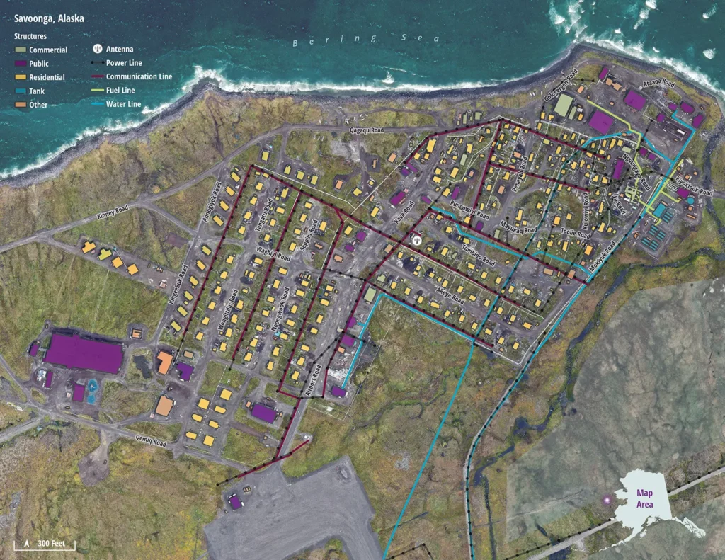
While some of the DCRA program’s oldest existing AutoCAD data could be converted into a usable GIS file geodatabase format, for example, updating details such as structures, utility systems, and transportation features required incorporating recent, high-quality imagery to augment the aging records.
Using Esri Imagery to Perform Feature Extractions
Ultimately, we were able create new vector data using a trove of recently collected imagery made available by Esri. From this source, and with special permission from Esri, we performed feature extraction for nearly 50 of the project communities. We also oversaw drone imaging surveys, acquired by partner firm Alaska Remote Imaging for nine communities where existing imagery fell short of project requirements.
The new imagery depicted ground and built features with a level of detail unimaginable during the days of the original DCRA program.”
Caitlin Vernlund, Hillary Palmer, and Shira Ellenson
Rebuilding the program also meant establishing new community-level contacts with local officials and infrastructure owners who could validate and update information on natural and built features, and provide input that would make the resulting products more relevant to their needs. Thanks to our community outreach consultant/tribal liaison, Nasruk Nay Consulting, we were able to quickly narrow the search for the appropriate contacts in each locality, and obtain critical information about culturally significant areas and other details to incorporate into the maps.
Delivering a Comprehensive Geodatabase
The success of the pilot project can be measured in many ways, beginning with delivery of a comprehensive geodatabase of updated data, along with recent imagery, metadata, and PDF format maps. Hosted by NOAA’s Digital Coast, Esri’s ArcGIS Living Atlas tools, and the State of Alaska’s Geoportal, the data will be easily accessible to support a variety of federal, state, and community-level planning and response needs.
We’ve also collected a wealth of experiences that will help Alaska address its ever-increasing need for accurate mapping data for climate, development, and environmental monitoring needs, particularly getting a head start on addressing potential challenges during the all-important planning phase.
Perhaps most importantly, the pilot project served as a reminder of the community mapping program’s multifaceted value to the communities and other users, and its worthiness for new investment as funding becomes available.
About the Authors

Hillary Palmer

Caitlin Vernlund