Skip to Content

New LiDAR Quality Level Terms Are Emerging

For the National Enhanced Elevation Assessment, being performed by Dewberry for sponsoring agencies of the National Digital Elevation Program, new “quality level” (QL) terminology has emerged for elevation data produced by different technologies with different vertical accuracy and horizontal…

By Dave Maune

For the National Enhanced Elevation Assessment, being performed by Dewberry for sponsoring agencies of the National Digital Elevation Program, new “quality level” (QL) terminology has emerged for elevation data produced by different technologies with different vertical accuracy and horizontal resolution specifications.

These QLs are quickly gaining national acceptance. During several national conferences this year, we have heard participants discuss LiDAR QLs 1, 2, and 3 as though everyone understands the meaning of these terms. Four out of the five QLs are straight forward. Only QL4 digital elevation models (DEMs), produced from existing stereo imagery typically used for digital orthophotos, vary significantly because of different image acquisition flying heights and image pixel resolution.

In case you are unfamiliar with elevation data QLs, you may benefit from studying the table below to get a better understanding.
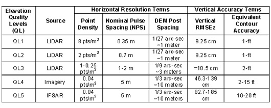
LiDAR-QLs
These Dewberry Quality Level terms may enter the national lexicon in the future.

About the Author

Dave Maune

Dave Maune

Related Insights

Integrating lidar and other 3D data into GIS gives utilities a detailed view of terrain and infrastructure, enabling more accurate transmission line and substation design, clearance analysis, and project planning.

August 20, 2026

Electric power utilities face many challenges today — rising power and supply chain costs, sharply increasing demand from large loads like data centers, major changes in federal energy policies, and a growing imperative to invest in grid hardening and resilience.

Blog

A screenshot of the Prepare St. Pete weather risk application.

November 6, 2025

When you live in an area that is high risk for potentially devastating natural weather events, communication between local officials and residents is critical, and in some cases, can mean the difference between life and death.

Blog

Dimensions®

Our annual review and corporate social responsibility report, in one place.