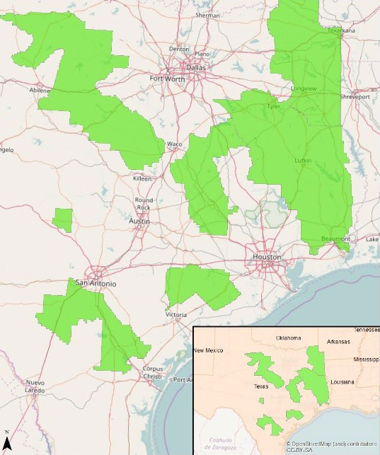
Dewberry has been tasked with facilitating, acquiring, and processing lidar data across Texas’ Red River and Neches Basin areas. The data, which cover more than 49,000 square miles, will support the U.S. Geological Survey’s 3D Elevation Program (USGS 3DEP) and Federal Emergency Management Agency’s (FEMA) Risk Mapping, Assessment, and Planning (Risk MAP) program.
Dewberry has been tasked under the USGS Geospatial Products and Services Contract (GPSC3) to collect and process quality level 2 (QL2) lidar topographic data across more than 50 Texas counties between Dallas, Houston, Austin, and the Texas/Louisiana border. The firm will oversee the data collection being conducted by four subconsultants and perform quality control, post-processing, and data classification. Dewberry will collect breaklines required to hydro-flatten inland ponds, lakes, streams, rivers, as well as tidal and non-tidal boundary waters after extracting hydrographic feature geometry using point cloud information and intensity imagery.
“East Central Texas is well known as an at-risk area for severe flooding,” said Dewberry senior project manager Elise MacPherson. “Increased development, urbanization, and the effects of global climate change have resulted in the need for up-to-date information. This project will help FEMA provide thousands of residents with updated reference data that they can use to keep their families and property safe.”
“The USGS National Geospatial Technical Operations Center (NGTOC) entrusted us to acquire and process 49,332 square miles of lidar data in Texas, and we responded by providing eight lidar sensors from our various subcontractors to complete this job,” said Amar Nayegandhi, Dewberry vice president and program manager for the USGS GPSC3 contract. “We have a long history of providing high-quality, cost-effective lidar data products and services to USGS. We continue to serve USGS and its partners with the most appropriate technology and products for each project.”