Many people are surprised to learn that the Arizona desert can experience extreme flooding. Flash floods, which can occur after intense thunderstorms, are particularly hazardous in low-lying areas as they can happen very quickly. In Maricopa County, part of the Phoenix metropolitan area, flood risks increase substantially during the monsoon season from July through mid-October, when the region receives approximately 80 percent of its annual precipitation.
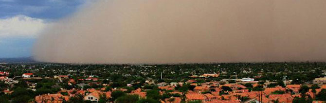
The Phoenix area is also at risk for extreme wind and lightning hazards, as well as the recent “haboobs” or dust storms that can wreak havoc in communities, especially for drivers. In early July, for example, a mile-high dust storm moved through the area, causing highways and airports to close. This great “wall of dust” was nearly 100 miles wide, and moved at speeds of 50 to 60 miles per hour.
Alerting emergency managers, public safety representatives, and the general public to these perils is the top priority for the Flood Control District of Maricopa County. Since August, we have worked closely with hydro-meteorologists from the district to monitor the weather and provide timely warnings regarding the potential for flash flooding and other hazards within the county’s 5,400 square miles. Our Meteorological Services Program provides weather forecasts and warnings to the district on a 24/7 basis. The district then transmits the information to emergency managers, police and fire departments, municipal highway and public works departments, and recreation areas. We use an Internet-based weather center to monitor national weather radar and satellite information as well as many operational numerical weather models.
It’s critical work that requires vigilance, around-the-clock hours, and an ability to optimize the array of technological and communications tools now available to monitor the weather. Having worked in meteorology and atmospheric science for more than 20 years, I’m grateful for these exceptional resources and the impact they now have in protecting public safety. I’m also pleased to see the integration of this science into the engineering field, where we can help deliver advanced flood warning systems and comprehensive hazard mitigation plans. Throughout my career, I’ve learned firsthand that science and engineering should go hand in hand, and that both should have a healthy respect for nature.